Endüstriyel Drone Uygulamaları
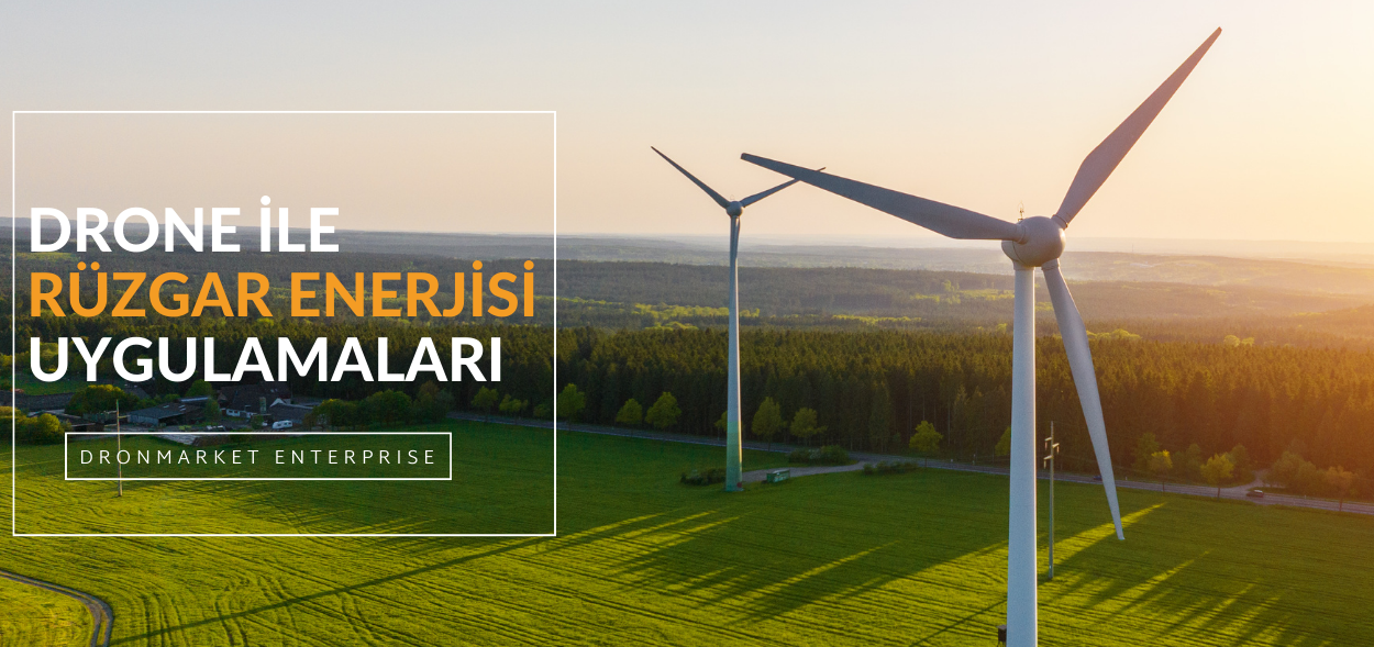
Rüzgar Enerjisi Sektöründe Drone Kullanımı
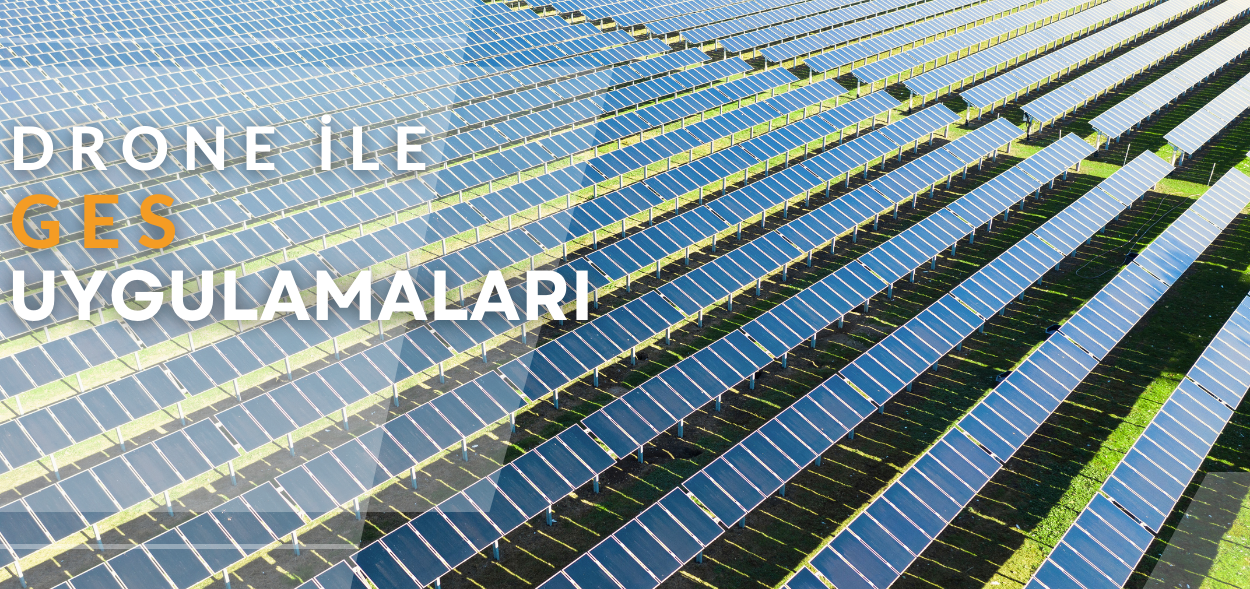
Güneş Enerjisi Sektöründe Drone Kullanımı
Hidroelektrik Sektöründe Drone Kullanımı
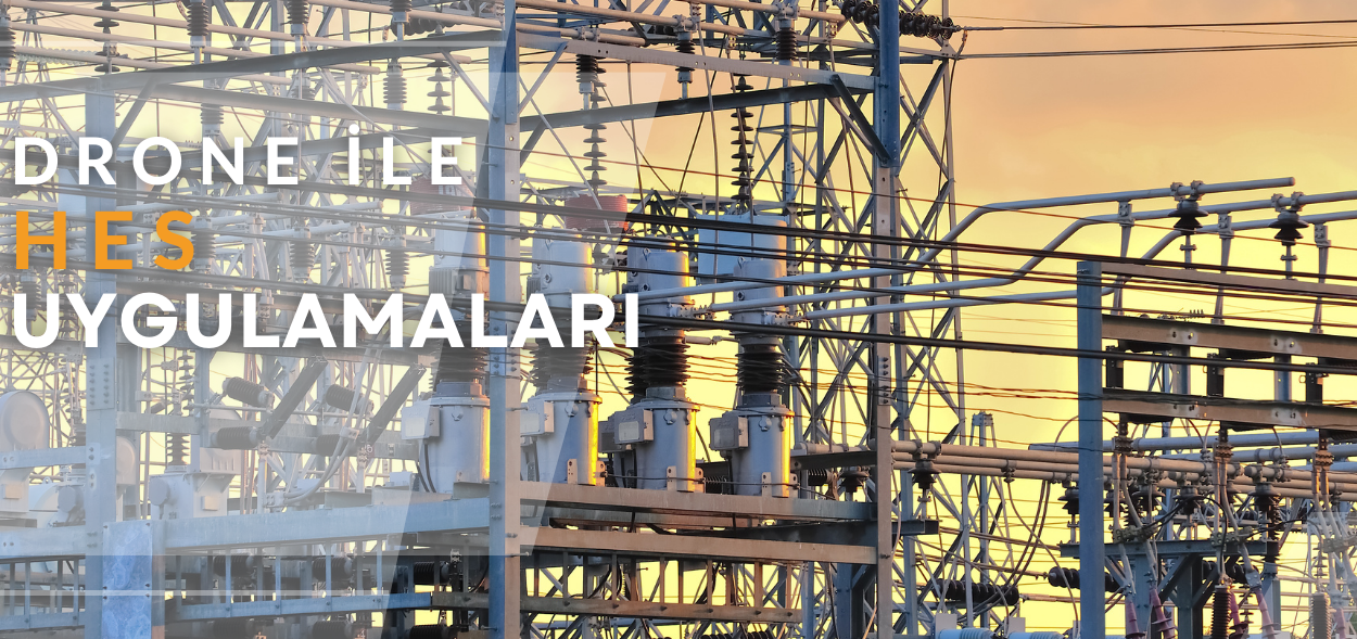
Rüzgar türbinleri ile bağlı olarak çalıştırılan yüksek gerilimli hidroelektrik santrallerinde de drone teknolojisinden faydalanılır. Özellikle hidroelektrik santraller ile bunların kurulum yerinin tespit edilmesi, üç boyutlu şekilde modellenmesi, çevresi ile birlikte haritalanması ve pek çok elektrik değerinin ölçülmesi için drone kullanılabilir. Bununla birlikte yüksek gerilim alanlarında ulaşımın tehlikeli olan noktaların denetlemesi sırasında hiçbir insan tehlikeye atılmadan uçuş yapılabilir.
Elektrik Nakil Hatlarında Drone Kullanımı
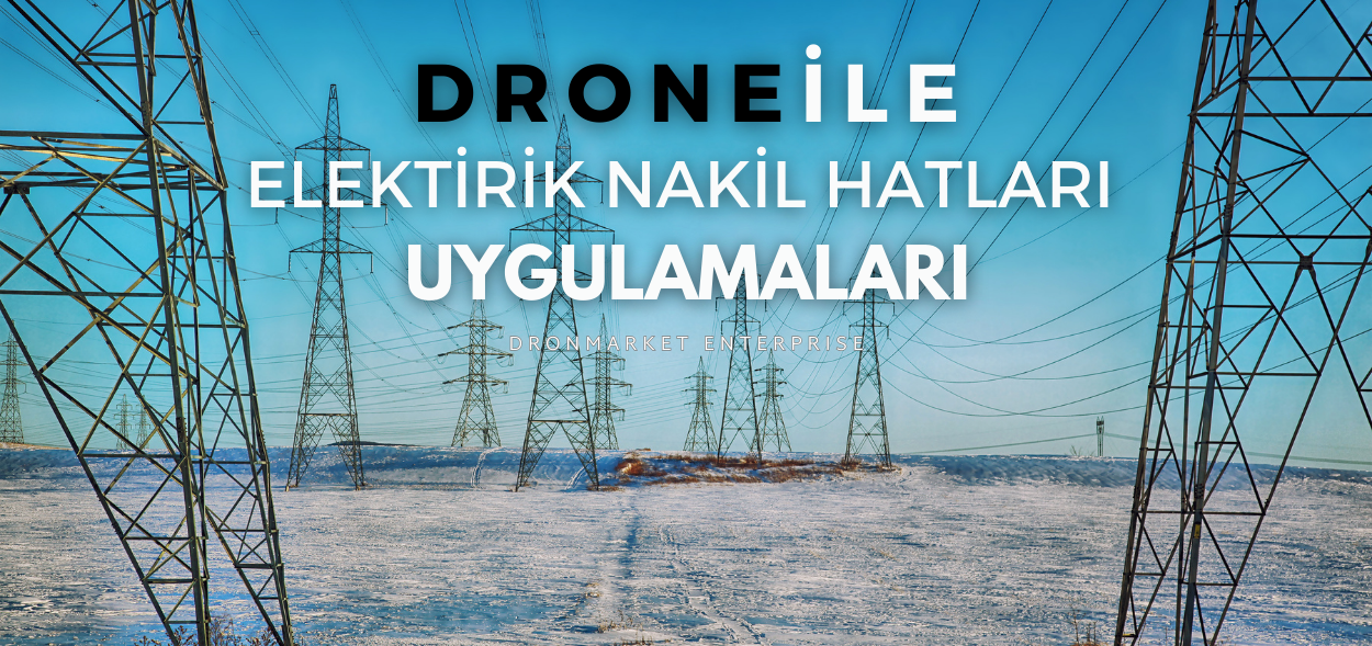
Standart elektrik hatları denetim süreclerinde zaman, maliyet ve tehlike arz ettiği için elektrik nakil hatları drone ile daha güvenli bir şekilde kontrol edilmektedir. Drone' larla yüksek canlı voltajlı elektrik hatlarına yakın uçabilir veyahut zoom özellikli faydalı yük taşıyabilen sistemleriyle, elektrik nakil hatlarına yaklaşmadan santimetre düzeyinde herhangi bir elektrik kesintisi ve aksama olmadan ayrıntılı incelemeler yapabilirsiniz. Drone ile çalışan bir Lidar taraması, optimum perspektiflerden yüksek kaliteli resimler sağlar, bu da aşırı büyümüş yeşillikleri veya diğer tıkanıklıkları kolayca belirleyebilir ve sorunları önceden farkedip tanımlamaya yardımcı olur.
Hasar Tespiti ve Bakım: Elektrik nakil hatlarında meydana gelen hasarlar, hızlı bir şekilde tespit edilmeli ve giderilmelidir. Dronelar, hatların üzerindeki hasarları belirlemek için kullanılabilir. Termal kameralarla donatılan dronelar, hatlardaki sıcaklık değişikliklerini izleyebilir ve potansiyel arızaları tespit edebilir. Bu sayede, bakım ekipleri hasarlı bölgelere hızla müdahale edebilir.
Çevresel İzleme: Elektrik nakil hatlarının çevresel etkileri izlenmeli ve değerlendirilmelidir. Dronelar, bu hatların çevresindeki doğal yaşamı, bitki örtüsünü ve çevresel değişiklikleri izlemek için kullanılabilir. Özellikle ormanlık alanlarda bulunan hatlar için droneların kullanımı, doğal yaşamın korunması açısından önemlidir.
Güvenlik Denetimleri: Elektrik nakil hatlarının güvenliği düzenli olarak denetlenmelidir. Dronelar, bu hatların çevresindeki güvenlik önlemlerini izlemek ve değerlendirmek için kullanılabilir. Örneğin, güvenlik çitleri, işaret levhaları ve erişim noktaları gibi önlemlerin varlığı dronelar aracılığıyla kontrol edilebilir.
Elektrik nakil hatlarında drone kullanımı, hatların düzenli olarak izlenmesi, hasar tespiti ve çevresel izleme gibi birçok fayda sağlar. Bu sayede, elektrik şirketleri hatların güvenliğini ve verimliliğini artırabilir, bakım maliyetlerini düşürebilir ve çevresel etkileri azaltabilir.
Arama Kurtarma Alanında Drone Kullanımı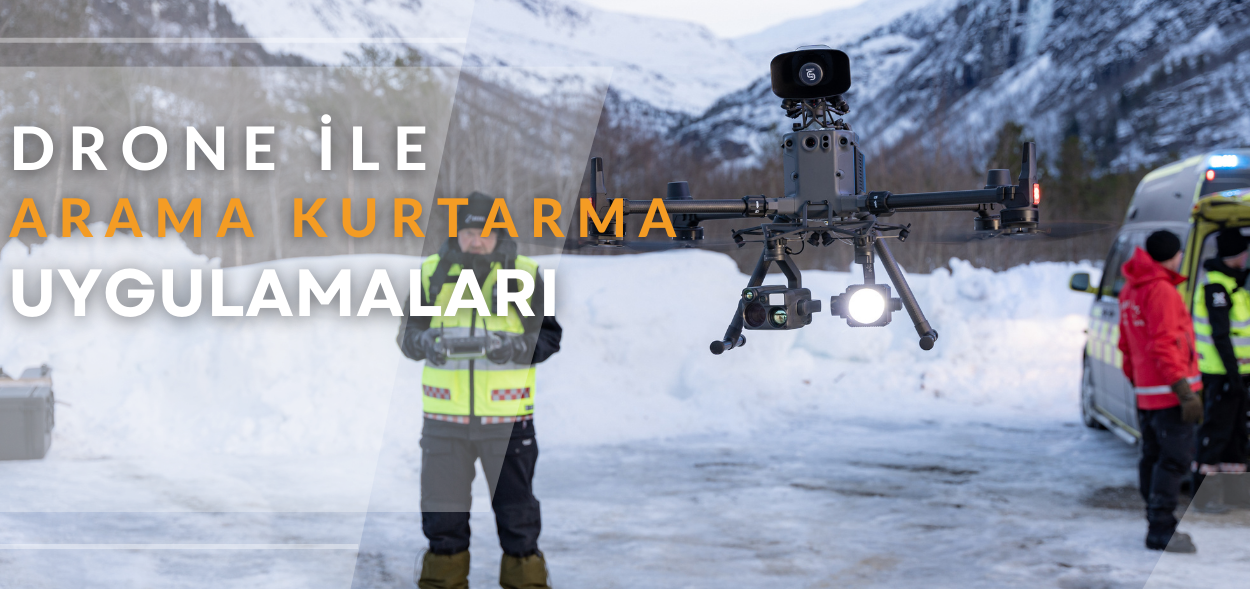
Hız ve Erişim Kolaylığı: Drone'lar, geleneksel arama kurtarma ekiplerinden daha hızlı bir şekilde saha üzerinde hareket edebilir ve zorlu arazi koşullarına daha kolay erişebilir. Bu sayede, kaybolan kişilerin bulunması için değerli zaman kazanılabilir.
Gözetleme ve İzleme: Drone'lar, yüksek çözünürlüklü kameralar ve termal görüntüleme sistemleri sayesinde geniş alanları kısa sürede tarayabilir. Bu sayede, kaybolan kişilerin veya acil durumda olan bölgelerin izlenmesi ve gözetlenmesi sağlanabilir.
Gelişmiş Sensörler: Bazı arama kurtarma drone'ları, GPS, lazer mesafe ölçümü, hava kalitesi sensörleri ve diğer gelişmiş sensörlerle donatılmıştır. Bu sensörler, kayıp kişilerin veya acil durum bölgelerinin belirlenmesi ve izlenmesine yardımcı olabilir.
Gece ve Zorlu Hava Koşullarında Kullanım: Termal kameralar ve gece görüş sistemleriyle donatılan drone'lar, gece ve kötü hava koşullarında bile etkin bir şekilde kullanılabilir. Bu özellikler, arama kurtarma operasyonlarının sürekli olarak devam etmesini sağlar.
Veri Aktarımı ve Analizi: Drone'lar, gerçek zamanlı olarak görüntü ve veri aktarımı yapabilir. Bu veriler, arama kurtarma ekiplerine hızlı kararlar almaları ve operasyonları daha etkin bir şekilde yönetmeleri için önemli bilgiler sağlar.
Bu özellikler sayesinde, drone'lar arama kurtarma operasyonlarında önemli bir rol oynamaktadır. Hızlı tepki, geniş kapsama alanı ve gelişmiş sensörlerle donatılmış olmaları, drone'ları kayıp kişilerin veya acil durum bölgelerinin tespitinde ve kurtarılmasında etkili bir araç haline getirir.
Güvenlik Alanında Drone Kullanamı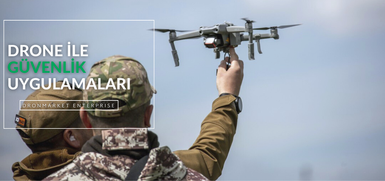
Güvenlik ve askeriye alanında drone kullanımı, birçok farklı amaç için yaygın olarak benimsenmiştir. İşte bu kullanım alanlarından bazıları:
Gözetleme ve Keşif: Askeri drone'lar genellikle düşman hareketlerini izlemek ve tespit etmek için kullanılır. Yüksek çözünürlüklü kameralar ve diğer sensörlerle donatılan drone'lar, düşman konumlarını belirlemek ve stratejik bilgiler toplamak için kullanılır.
Hedef Tespiti ve İzleme: Askeri drone'lar, hedefleri belirlemek ve izlemek için kullanılır. Özellikle hassas hedeflerin tespiti ve izlenmesi gerektiğinde, drone'lar doğrudan hedefe yakın bir şekilde çalışabilir ve gerçek zamanlı bilgi sağlayabilir.
İstihbarat Toplama: Askeri drone'lar, düşman güçlerinin hareketlerini izlemek ve istihbarat toplamak için kullanılır. Bu, düşmanın stratejik hedeflerini belirlemek ve askeri operasyonları planlamak için önemli bir bilgi kaynağı sağlar.
Hava Keşfi ve İzleme: Askeri drone'lar, hava sahasında keşif ve izleme görevleri için kullanılabilir. Örneğin, hava savunma sistemlerinin tespiti ve düşman hava araçlarının izlenmesi gibi görevlerde drone'lar etkili bir şekilde kullanılabilir.
İnsansız Operasyonlar: Askeri drone'lar, tehlikeli veya düşman hatlarında gerçekleştirilecek operasyonlarda kullanılabilir. İnsansız drone'lar, askeri personelin güvenliğini riske atmadan stratejik hedeflere saldırabilir veya keşif yapabilir.
Konvoy ve Konum Koruma: Askeri drone'lar, konvoyların ve askeri birliklerin güvenliğini sağlamak için kullanılabilir. Drone'lar, konvoyların etrafında devriye gezerek potansiyel tehditleri tespit edebilir ve askeri birliklerin konumlarını koruyabilir.
Bu gibi birçok farklı amaç için, askeri ve güvenlik güçleri drone teknolojisini aktif olarak kullanmaktadır. Drönlerin bu alanlarda kullanımı, operasyonların etkinliğini artırırken askeri personelin güvenliğini de sağlamaktadır.