Agriculture Drone Applications


Agriculture Drone Applications
Drone technology is one of the extraordinary innovations that continues to be influential in many sectors today, making life and the way of doing business easier. Drone technology is frequently used in sectors such as construction, mapping, industry, security. Another of these , the use of drones in agriculture, is to use high-tech tools for the development of modern agriculture. Agricultural drone applications can be exploited from crop monitoring to livestock management, spraying, irrigation, mapping and much more, while hi-tech drones help both farmers and pilots flying drones be actively involved in every aspect of the farming process.
Advantages of Using Drones in Agriculture
Agricultural drone types used in agricultural areas can be preferred as both multi-engine and fixed-wing. Multi-engine systems are relatively easy to use. The sensors on the drone, cameras with special spraying, digital imaging capabilities and transmission enable people engaged in agriculture to get richer images and data from the field. While the effect on the product is around 40% in tractor spraying, this rate rises to 90% in drone spraying. While the waste of medicine is too much with the tractor, 35% and 40% of the medicine can be saved with the drone. While it is possible to spray an average of 300 decares per day with the tractor, it is possible to spray an area of 800 decares with the drone. In addition, drones, which are extremely important for human health, will add an added value since they are not in contact with the drug. Thus, both up-to-date data can be collected in the agricultural sector and time and money can be saved while increasing the product yield.
The operations that can be carried out with agricultural drones today can be summarized as follows:
Soil and field analysis
One of the biggest advantages of using agricultural drone technology is the ease of monitoring large-scale crops and plantations. Although satellites and aircraft with large-scale views have been used to detect potential problems in the past, these are technologies that are both expensive and cannot compete with drones in precision. Agricultural drones, on the other hand, provide not only real-time images, but also animations showing the development of the product in real time.
Agricultural drone variants provide three-dimensional maps of the existing soil, allowing detailed inspection of soil quality, nutrient management or dead soil areas. This important information can help the farmer identify effective patterns in planting, crop management, soil, crop analysis and much more. On the other hand, continuous monitoring can enable better use of water resources and more effective management of crop nutrient levels. Your biggest assistant in these situations is Phantom 4 Multispectral.
DJI Phantom 4 Multispectral Drone Kit

You can gather high-precision data using the Phantom 4 Multispectral, a high-precision drone with a seamlessly integrated multi-spectrum imaging system designed for farming missions, environmental monitoring and more.
- - Integrated Multispectral Imaging System
- - Centimeter Precision RTK Positioning System
- - Compatibility with D-RTK 2 Ground Station
- - Possibility to switch between real-time views of RGB video camera during Operation and NDVI (Normalized Differential Vegetation Index) for instant on-site information.
- - It has a gimbal-stabilized imaging system consisting of an RGB camera and a multispectral camera array with five narrowband sensors, including red-edged and near-infrared, capable of receiving visible and invisible light. These data provide trained professionals with unique insights into vegetation stress, soil composition, water salinity, and pollution. An additional integrated spectral sunlight sensor maximizes the accuracy and consistency of data collection during missions flying at different times of the day.
- - The Phantom 4 Multispectral combines data from six individual sensors to measure the health of crops, from individual plants to entire fields, weeds, insects and various soil conditions.
- - Provides farmers and agronomists with a new tool to increase crop yields, reduce costs, and help environmental experts easily monitor vegetation on the land they manage.
- - Across all seasons, multispectral images can help farmers by providing information across the electromagnetic spectrum that is invisible to the human eye. By accessing this data and subsequent Crop Index data such as NDRE and NDVI, farmers can make timely and informed decisions about crop processing, reducing costs, conserving resources and maximizing yields.
Spraying and Irrigation
Crops in agricultural areas need periodic fertilization and spraying to maintain high yields. This process, which can traditionally be done by hand or through agricultural machinery , can be both time consuming and costly. The model used when spraying with a drone can be equipped with a special capsule filled with fertilizers, herbicides or pesticides. Thus, field spraying with a drone can continue in the desired area or in a point area, both in the form of spraying and fertilization. The drone spraying models used for this purpose can be operated completely independently, or they can be adjusted to work on certain programs and routes. Moreover, agricultural spraying drone prices even provide a cost advantage in the long run compared to the manual process. In particular, while it saves 30% - 35% of pesticides from spraying with traditional agricultural machines, while the effect on the product is around 40% in pesticides made with traditional methods, the effect on the products is around 90% and 20% more water-saving in drone spraying, with planned flights without entering the field with traditional methods. . There is no need to enter the field, and the situation of damaging the products is also eliminated. Irrigation in agricultural areas is a very laborious task. In addition, the determination of the area to be irrigated is an important parameter. Agricultural drones equipped with specialized multispectral cameras can help identify areas of soil that need irrigation by monitoring moisture levels. Your supporter to meet all these needs is DJI AGRAS T20, DJI AGRAS T16, DJI AGRAS MG1-P agricultural drones.
Dji Agras T30 Agricultural Spraying Drone
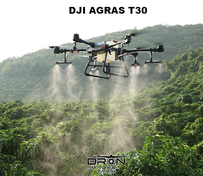
DJI Agras T30 Features:
- • 90% Water Saving Compared to Traditional Methods
- • 30 Liter Tank Capacity
- • 9 Meter Spraying Width
- • 16 Spraying Nozzles
- • 170-265 µm Droplet Size
- • Spraying Capability of Up to 180 Decares of Land per Hour
- • No More Fuel Expenses Due to Tractor Usage
- • Balanced Spraying Method
- • Drug Savings Up To 40% Compared To Traditional Methods
- • No Loss of Yield Due to Tractor Wheel Tracks !
- • Spraying up to 1,500 decares per day
- • Fully Automatic Spraying Capability
- • Internal Mission Planning and Monitoring Screen
- • 2 Pump System with Electromagnetic Flow Meter
- • Front and Back Dual Cameras
- • 5 Km Remote Control Support
- • IP67 Protection System
- • Omnidirectional and Upward Radar
- • Real-Time Warehouse Level Information and Refill Reminder Ability
- • Terrain Elevation Tracking Capability
DJI Agras T20 Agricultural Spraying Drone
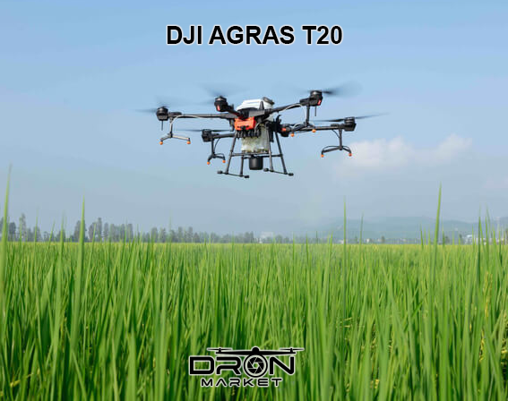
With its powerful performance and outstanding spraying capabilities, the T20 performs autonomous operations in a variety of terrains, such as large fields, terraces and orchards. New features such as omnidirectional digital radar help the T20 take stability and flight safety to the next level, providing users with highly efficient results.
- -20 Liter spray tank
- -Autonomous high precision operation
- -IP67 rating
- -Omnidirectional digital radar
- -Real-time visual monitoring system
- -AL Smart farming engine
Increase Efficiency
The T20 has a 20 L payload combined with a 7 m spray width, making operation more efficient.
Effortless And Precise
A comprehensive spray system, the T20 allows users to easily adjust flight and operating parameters. With the built-in RTK centimeter-level positioning system and RTK dongles, centimeter-level waypoint registration is enabled, which greatly strengthens operations and ensures precise spraying.
Big Power, Great Performance
The T20 is equipped with 8 nozzles and high volume pumps capable of spraying at speeds up to 6 L/min. A highly optimized wind field produces droplets ideal for size and consistency. The T20 is also equipped with a new 4-channel electromagnetic flowmeter that monitors and controls four hoses separately, providing an efficient flow rate for each nozzle.
Increased Flight Safety
The T20 is equipped with an omnidirectional digital radar that can detect obstacles from all horizontal directions. It also provides a high level of operational safety by automatically overcoming obstacles when flying over various terrains. With this radar, the T20 can adapt to most environments 24/7, thanks to its strong resistance to dust and water. The T20 also comes with a real-time FPV camera and two projectors, providing users with comprehensive live images even at night.
Incredibly Durable and Enhanced Portability
With a robust modular design, the T20 folds and unfolds in seconds, making it more portable than other agricultural drones. The spray tank and battery are replaceable, which reduces downtime and significantly improves workflow. All core modules are IP67 rated. They can also resist water splashes while cleaning the airframe, which can be easily done with water. Calibration and maintenance have become incredibly easy thanks to the 4-channel electromagnetic flowmeter, 4 electromagnetic exhaust valves and replaceable diaphragms for the pumps. In addition, air bubbles can be evacuated at the push of a button.
Brand New Agras Smart Controller
DJI has successfully upgraded the T20's performance thanks to the new programmable Agras Smart Controller 2.0 and the DJI Agras app. The user interface runs smoothly and is incredibly intuitive. In addition, the smart controller has an ultra-bright 5.5-inch display that can be seen even under strong sunlight. It also supports external battery packs and can last twice as long as other remotes, perfect for long or heavy workloads.
DJI Agras T16 Agricultural Spraying Drone
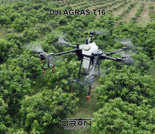
Different Modes for Different Needs
- -Mountains: An outstanding propulsion system and tilt angle sensing technology make it easy to use in mountainous terrain.
- -Orchards: Use DJI Terra with T16 to create a 3D model of the operation area and identify fruit trees with AI technology. Then create 3D operation plans based on tree distribution and altitude.
- -Flat Ground: Manual Operation Mode, AB Route Operation Mode and Route Operation Mode are available to meet most operational needs.
- -Phantom 4 RTK: Centimeter-level positioning, high-precision data acquisition, 247-acre image acquisition in 25 minutes
- -DJI Terra: Real-time mapping, 2D/3D modeling, AI operations planning
- -DJI Agricultural Steering Platform: Operations data management, personnel arrangement
- -DJI AGRAS T16: 24.7 acres of high efficiency work in 1 Hour

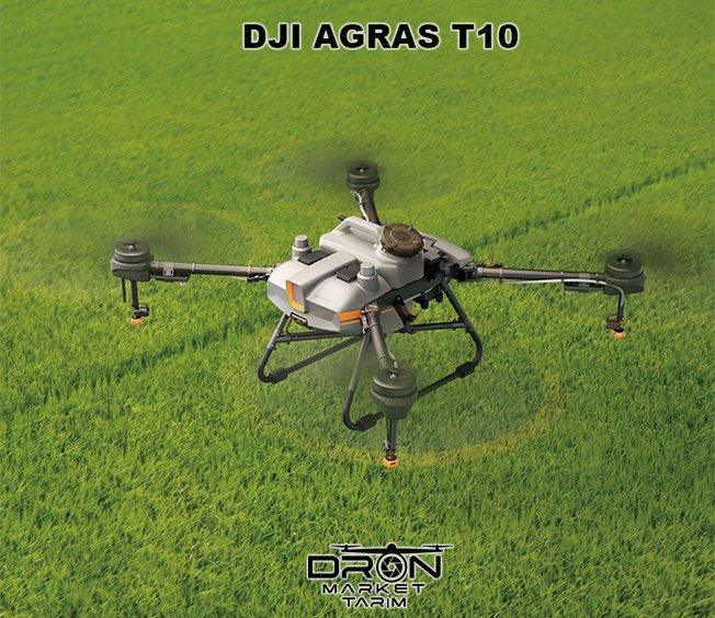
DJI Agras T10 Features:
- • 90% Water Saving Compared to Traditional Methods
- • 10 Liter Tank Capacity
- • 5 Meter Spraying Width
- • 4 Spraying Nozzles
- • 130 - 250 µm Droplet Size
- • Spraying Capability of Up to 60 Decares of Land per Hour
- • No More Fuel Expenses Due to Tractor Usage
- • Balanced Spraying Method
- • Drug Savings Up To 40% Compared To Traditional Methods
- • No Loss of Yield Due to Tractor Wheel Tracks !
- • Spraying Up to 600 Decares a Day
- • Fully Automatic Spraying Capability
- • Internal Mission Planning and Monitoring Screen
- • 2 Pump System with Electromagnetic Flow Meter
- • Front and Back Dual Cameras
- • 5 Km Remote Control Support
- • IP67 Protection System
- • Omnidirectional and Upward Radar
- • Real-Time Warehouse Level Information and Refill Reminder Ability
- • Terrain Elevation Tracking Capability
DJI AGRAS MG1-P Agrochemical Drone